Best Motorcycle Rides in Oregon
Are you searching the question, “What are the best motorcycle rides near me in Oregon?” If you are, then check out this list for the Top 7 Best Oregon Motorcycle Rides. We’ve included the Google maps motorcycle route maps, so you can begin your epic motorcycle trip in Oregon!
MOTORCYCLE RIDES NEAR ME IN OREGON
These twisty motorcycle routes include parks from Crater Lake to Mount Hood. There’s also amazing seaside towns like Cannon Beach. Ride along hundreds of miles of coastline, thick forests, mountains, raging rivers and waterfalls. This list will answer your question: What are the best motorcycle rides near me in Oregon (OR)?
TIPS FOR OREGON MOTORCYCLE RIDES
If you’re looking for places to ride a motorcycle in Oregon, keep in mind given it’s diverse geography and weather, riders could need everything from well-vented summer gear to insulative rain gear that will keep you from being soaked. If riding in the desert region of the the southeast, be sure to travel with plenty of water.
IS THERE A HELMET LAW IN OREGON?
While your discovering these scenic motorcycle trips in Oregon, be aware of the state’s law regarding motorcycle helmets. Oregon requires riders to wear a motorcycle helmet as either an operator or passenger.
Read more:
oregon.gov

JOIN US ON YOUTUBE!
Check out our YouTube video on the Best Motorcycle Routes in Oregon! Experience what it’s like to motorcycle the amazing Crater Lake National Park as well as the stunning Shaniko Fossil Highway. Join our 43K subscribers on YouTube!
1. Route 138 to Crater Lake
ROUTES: OR-138, Volcanic Legacy Scenic Byway
DISTANCE: 228 miles
TIME: 5 hours
Route 138 runs alongside the Umpqua River, beside Diamond Lake and leads to Crater Lake National Park, making it one of the best motorcycle roads in Oregon. The loop around the Volcanic Legacy Scenic Byway is a fantastic loop around this incredible natural wonder with astounding views. The scale of the lake is difficult to wrap your head around, you have to see it in person. At over 6,000 feet of elevation, the lake itself is nearly 2,000 feet deep. It’s one of the clearest, cleanest, and deepest bodies of water in the world. Be aware, however, that even in June there may be significant amounts of snow.
(photo: neilpeart.net)
Click here for the
Google maps motorcycle route link
2. The Devil’s Tail
ROUTE: OR-86
DISTANCE: 70 miles
TIME: 1.5 hours
Located on the border of Oregon and Idaho, Hells Canyon is the deepest canyon in North America – including the Grand Canyon. This motorcycle ride in Oregon lies between Baker City and Oxbow. It’s a challenging ride with an abundance of curves and elevation changes. The Devil’s Tail is a nickname bestowed by 2008 rally attendees on a 22-mile twisty segment of the road as a homage to the “Tail of the Dragon”. Ride this carefully and enjoy Eastern Oregon’s scenery.
(photo: flickr.com)
Click here for the
Google maps motorcycle route link
3. Lewiston Highway
ROUTE: OR-3
DISTANCE: 56 miles
TIME: 1 hour
This north/south 2-lane OR motorcycle ride has gorgeous scenery along the Snake River, and meanders through high mountain farm land. Enjoy the deep river gorges on the northern portion of this road. There’s some great tight curves in the Grande Ronde area. Riding south on this route leads to the serene Wallowa Lake State Park.
Click here for the Google maps motorcycle route link
4. Oregon Coast Highway
ROUTE: US-101
DISTANCE: 167 miles
TIME: 4 hours
Nothing beats riding on the coast of the Pacific on a sunny day. The Oregon Coast Highway is a fun ride with great ocean scenery. This route will take you high above the ocean but also brings you right along the beaches, with a mix of heavily forested sections through the evergreens. Overall, it’s a great curvy road with awesome views! Most of Route 101 will get a fair bit of traffic, but our favorite part of this stretch is between Crescent City, CA and Coos Bay, OR. The scenery is just as spectacular but there’s a lot less traffic.
Click here for the
Google maps motorcycle route link
EXPLORE MORE >>
5. Route 242
ROUTE: OR-242
DISTANCE: 37 miles
TIME: 1 hour
Oregon Route 242, known as a portion of the McKenzie Hwy, is a state highway that runs from Belknap Springs, Oregon through McKenzie Pass in the Oregon Cascades, to Sisters, Oregon. From the town of Sisters, the road ascends 2,000 feet, tracing an old 1860s wagon route. During the early part of the summer season you’ll ride through a corridor of snow embankments, past ancient lava fields and summit at Dee Wright Observatory, with unobstructed views of waterfalls and snow-capped mountains. This one is only open during the warmer months, due to its high elevations. Just watch out for some of the sharp curves having gravel from other vehicles that drifted off the pavement. You’ll want to take your time on this road, not only to ride it carefully, but also to just enjoy the fantastic scenery. For longer riding, continue on Hwy 126 to Eugene, which follows the McKenzie River through the Cascade Mountain range.
(photo: flickr.com)
Click here for the
Google maps motorcycle route link
6. Route 35
ROUTE: OR-35
DISTANCE: 40 miles
TIME: 1 hour
Starting up in Hood River, hop on Oregon Hwy 35 for an amazing ride through the Mt. Hood National Forest. There will be a ton of fantastic photo opportunities to catch the majesty Mount Hood, the 11,235 ft dormant volcano, which is Oregon’s highest point. Within a few miles from the start of the ride, you’ll soon be riding at the top of the Gorge looking down into valleys and across canyons. If you try this on a weekday, you’ll avoid a lot of traffic, and you’ll have plenty of opportunities to open up on this great Oregon motorcycle road. Optionally continue west along OR-26 for more exceptional riding heading back towards Portland, OR.
(photo: D. Coppedge)
Click here for the
Google maps motorcycle route link
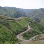
7. Shaniko Fossil Highway
ROUTE: OR-218
DISTANCE: 43 miles
TIME: 1 hour
For a great Oregon motorcycle ride in the high desert, check out the Shaniko Fossil Hwy. The road is very windy and hilly over its entire 43-mile length and motorcyclists will be treated with wide open vistas. It runs through the small town of Antelope, and has a junction with OR 293 on the south end of town. Shaniko Fossil Highway crosses the John Day River at Clarno with mountainous terrain in view. The John Day Fossil Beds National Monument is nearby and worth a look. Between Clarno and Fossil, the road has several sharp curves, with a posted speed limit of 15 miles per hour in several places. The views are simply astounding and the highway has virtually no other vehicles. Plan your fuel carefully, as there are virtually no amenities.
(photo: B. Swenson)
Click here for the
Google maps motorcycle route link
LOOKING FOR MORE?
Join us on Patreon to unlock these bonus features and more:
ROUTE PLANNING
Maps showing where routes are located within each US state.
GPX FILES
GPX files are available for download with each US motorcycle route.
EXCLUSIVE VIDEOS
Exclusive video content on the best motorcycle rides
MORE ROUTES
Bonus motorcycle routes for US & Canada
Frequently Asked Questions
Visit our friends at BikeWeekEvents.com to find local OR Motorcycle Rallies and all scheduled bike shows happening in Oregon!
Any bloggers or website articles that would like to use these routes, please refer to our TERMS OF USE.
Please note: Any routes and recommendations are based solely on our opinions and are meant for informational purposes only. To use information contained on this site is to do so at your own risk. GreatMotorcycleRoads.com is not responsible for the information contained in these pages. We assume no liability for decisions made as a result of the information provided here. You are responsible for your decisions, your actions, and your safety. By using this website you agree to the TERMS OF USE .
WHERE CAN I FIND SCENIC MOTORCYCLE ROUTES NEAR ME AROUND OREGON?
GreatMotorcycleRoads.com is the place to find the best motorcycle roads and rides near Oregon and the Northwest United States. Discover more great motorcycle roads in the Northwest US with our detailed route descriptions and Google Maps links!